Council has a duty of care to manage lands subject to flooding within its Local Government Area, under the NSW Government's Flood Prone Land Policy. Council is responsible for formulating and implementing Floodplain Risk Management Plans in accordance with the policy.
You can view Council's completed Floodplain Risk Management Plans on the plans and strategies page under Floodplain Risk Management Plans.
Find out the flood level of your property
Residents can obtain, for a fee, the flood level certificate for their property using Council’s online services via this link.
Have your say
Previous consultations - Thank you to everyone who shared their thoughts on these studies and plans:
- Lake Macquarie Catchments - Overland Flood Study
- Killarney Vale and Long Jetty Catchments - Floodplain Risk Management Study and Plan
- Wallarah Creek Catchment - Floodplain Risk Management Study and Plan
- Ourimbah Creek Floodplain Risk Management Study and Plan
- Woy Woy Peninsula Floodplain Risk Management Study and Plan
- Wyong River Floodplain Risk Management Study and Plan
- Northern Lakes Floodplain Risk Management Study and Plan
- Davistown and Empire Bay Floodplain Risk Management Study and Plan
- Woy Woy Peninsula Floodplain Risk Management Study and Plan
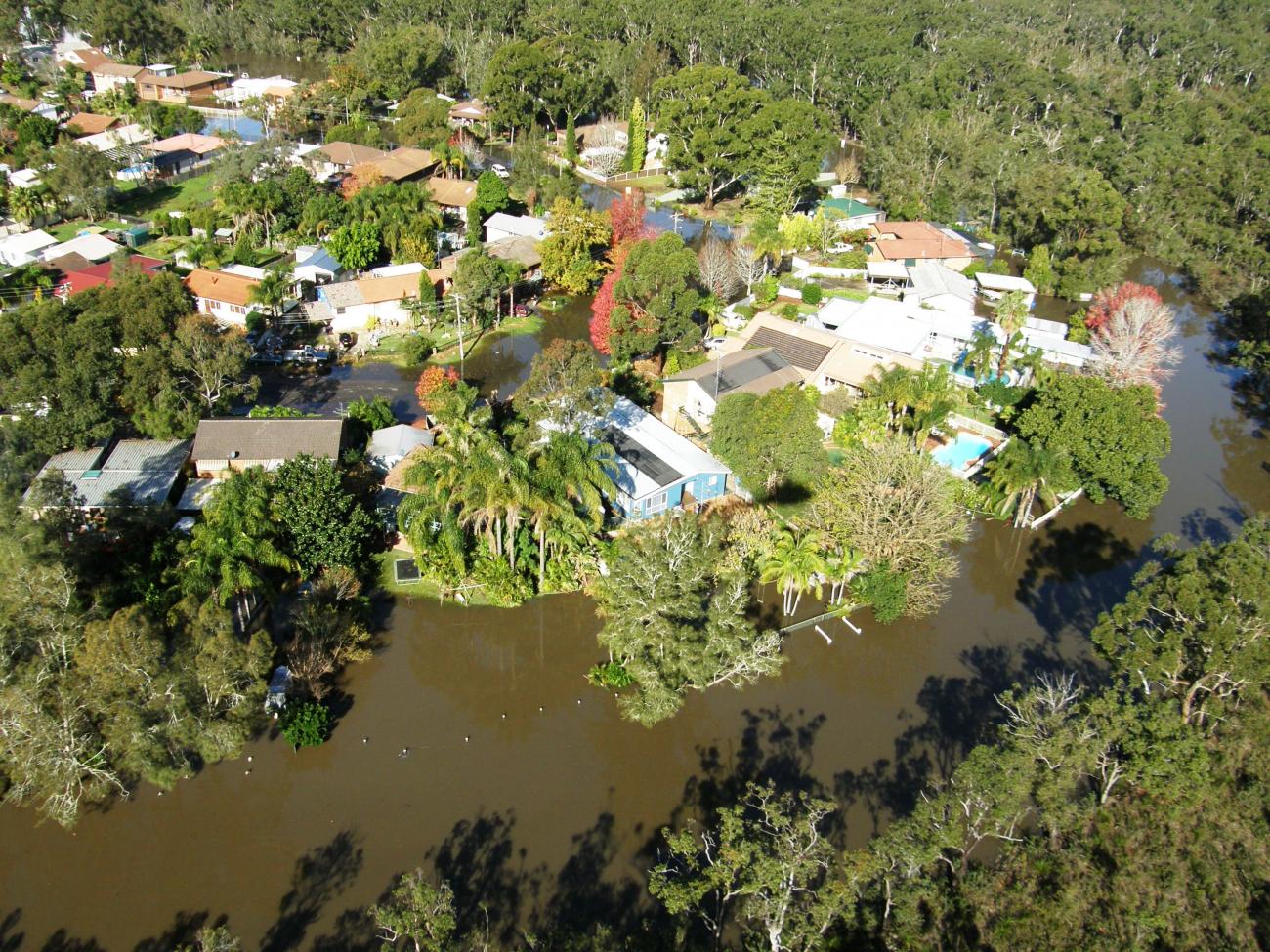
Flooding in Tuggerah Lakes
Central Coast Council has reliable flood records for Tuggerah Lakes that go back over 90 years. Since the documentation started, we have experienced 12 floods reaching a height of 1.5m above the Australian Height Datum (AHD or mAHD for metres above the Australian Height Datum) or more.
The highest flood recorded for the lakes was 2.10 mAHD in June 1949. The most recent flooding event happened in July 2022 with the lake reaching 1.72 mAHD. In February 2020 it reached 1.67 mAHD, followed closely by the ‘Pasha Bulker’ flood from June 2007 at 1.65 mAHD. The February 1990 and March 1977 floods also reached 1.6 mAHD.
This animation explores some of the complex estuary and coastal processes that interact when a flood comes, and the unique conditions of Tuggerah Lakes.
Got a question?
Make sure you check out our frequently asked questions below.
What is a floodplain risk management study?
A floodplain risk management study utilises the information from the preceding flood study to identify, assess and compare various flood risk management options and consider opportunities for environmental enhancements as part of flood mitigation works.
The management study provides information and tools to allow strategic assessment of the impacts of management options for existing, future and continuing flood risk on flood behaviour and hazard. It also allows for a robust assessment of the social, economic, environmental and cultural issues and costs and benefits of all options.
What is overland flooding?
Overland flooding is caused by excess rainfall runoff which flows across the land before it enters a creek or stream. A combination of factors lead to excess rainfall runoff including:
- inadequate drainage
- a build-up of impervious surfaces overtime (such as concrete surfaces)
- the ability of the ground to absorb water.
Overland flooding tends to affect localised areas rather than the whole suburb at once
How do I obtain flood information for my property?
Council has flood maps available for its main waterways which give an indication of areas that will most likely be affected by various flood events. However, these maps are not detailed enough to provide flood levels for individual properties.
If you require more detailed information from that supplied on the maps and in relation to a Development Application, residents of the Central Coast can obtain, for a fee, the flood level on their property using Council’s online services via this link.
Note: It is not Council's general practice to provide flood information about a property over the phone.
What is flash flooding?
Flooding that is sudden and unexpected is referred to as flash flooding. It is usually caused by intense thunderstorms which deposit a large amount of rainfall in a short period of time.
What causes flooding?
Flooding occurs when water covers land that is normally dry. Flooding may be due to heavy rains, overflowing of the rivers, creeks and waterways, broken dams, storm surges and tsunamis, lack of capacity in the drainage system, broken pipes and many other reasons.
What is the 1% AEP flood?
A 1:100 year Average Recurrence Interval is the result of statistical data which estimates the probability that a particular rainfall event (or intensity) will be equalled or exceeded at a particular place within a certain period of time, i.e., 100 years.
This is also referred to as the 1% Annual Exceedance Probability (AEP) flood, which is a flood that has a 1% chance of reaching or exceeding a particular magnitude in any one year.
It should be noted that if a 1% or 1 in 100 year flood is experienced in a certain year, that does not mean that there will not be another 1 in 100 year flood occurring in the same year or during the next 99 years. On average, if you live to be 70 years old, you have a better than even chance of experiencing a 1% AEP flood.
What is the probable maximum flood (PMF)?
The probable maximum flood (PMF) is the largest flood that could possibly occur. It is a very rare flood (much rarer than the 1% AEP flood). Despite this, a number of historical floods in Australia have approached the magnitude of a PMF. Every property potentially inundated by a PMF will have some flood risk, even if it is very small. Councils are required to consider all flood risks, even these potentially small ones, when managing floodplains.
Can flooding be prevented?
Flooding is a natural part of how waterways work. There will always be a possibility of flooding for various reasons and when large amounts of rain falls. However, infrastructure can be designed to reduce the impacts and risks of flooding by slowing the water down, stopping it reaching certain areas, or by having appropriate planning instruments in place to prevent building in flood prone areas.
Why does Council conduct studies and plans?
Flooding has the potential to cause considerable damage and disruption to a community. In addition to tangible damage, floods also impose high levels of intangible damage such as increased levels of stress on affected communities. Council undertakes studies so there is a better understanding of the flood hazard in the study area, and the information from the flood study will be used as the basis of a future floodplain risk management study for the area.
The main objectives of the floodplain risk management process are to:
- minimise risk to life, health and safety
- reduce flood damage to property and infrastructure in the existing community
- ensure future development is controlled in a manner which is compatible with a catchments flood risk
- protect and enhance the floodplain environment and be consistent with relevant state government policies
- ensure that the flood study and/or floodplain risk management study and plan has the support of the local community.
Why do flood levels change over time?
Flood levels are typically estimated using computer models. Computer models are the preferred method for establishing flood levels as they can be used simulate a range of floods including floods well in excess of those that have been experienced since settlement of the area. Given the importance of estimating flood levels accurately, Councils engage experts to establish and operate the computer models.
From time to time the computer models are revised and predicted flood levels can change. The resultant change in flood levels however is normally very small. The reasons why the computer models are revised can include:
- new rainfall or ground topography information becomes available
- new floods occur which provide additional data from which to fine-tune the models
- better computer models become available as the science of flood modelling improves and computer capabilities increase
- flood mitigation works may have been carried out, or development within the catchment may have occurred, that was not previously represented in the models.
Who is responsible for floodplain management?
In NSW, the roles and responsibilities for the management of flood-prone land are stated in the NSW Government’s 2005 Floodplain Development Manual (the Manual), and are shared between several agencies, including those listed below:
Council
The manual guides Councils through the process of floodplain risk management. Flood mitigation measures recommended by the manual fall within three broad categories and are followed by Council:
- Flood modification: retarding basins, levees and channel improvements
- Response modification: education, emergency response and recovery planning
- Property modification: planning and development controls, land zoning and building modification.
Examples of those measures include:
- preparation of floodplain risk management plans
- preparation of local environment plans (LEPs)
- local development under Part 4 of the Environmental Planning and Assessment Act 1979 (exempt development, complying development and development requiring consent)
- planning certificates
- asset management
- flood education
- emergency response and public infrastructure
- post flood data collection and reviews.
State Government
Through relevant government bodies, such as the Department of Planning, Industry and Environment, the state government’s roles include:
- support of policy through legislation
- definition of broad policy objectives
- provision of specialised technical advice
- provision of financial assistance
- provision of emergency management including recovery collection and reviews.
State Emergency Service
- act as the lead agency for coordinating evacuation and welfare during flood events.
Is my house protected by flood mitigation measures?
Many areas on the Central Coast have flood mitigation measures in place. These measures may include a levee bank, a channel that has been widened, a floodgate, a detention basin or larger drains which aim to reduce the frequency of flooding and the length of time the stormwater remains on flood liable properties.
However, these measures can fail in severe and prolonged storm events, therefore it is important to be prepared for a major flood if your house is located on identified flood liable land or within close proximity to a creek, water course, water body, depression, etc.
To find out whether your property is within an area identified as being affected by flooding up to a 1% AEP flood event, please refer to the flood mapping section.
Am I liable for any work I do in a drainage easement, flood area or watercourse?
In short, yes. A solution to solving your problem may adversely affect your neighbour. You should not construct any works that divert stormwater flows onto your neighbour’s property as you could be held liable by your neighbour for any damage as a result of such action.
A common problem in built up residential areas is the construction of boundary fences and gates which impede natural overland flow paths.
You should be careful, when making these types of improvements to your property, that you choose construction materials which will not dam or divert overland flood waters. These types of improvement works may require development approval if located within a floodplain or overland flow path.
Likewise, placing fill on flood liable land may cause an increase in floodwaters upstream and downstream. Placing fill around your house and blocking or diverting pipes may also lead to serious flooding problems either to yourself or your neighbours. Many properties which were once flood free can be made flood liable because of these types of works.
You should always check with Council before placing any fill material on or near an existing pipeline, overland flow path or watercourse.
Similarly, do not attempt to change the location of a natural watercourse. There is a good reason why nature has placed the watercourse in that location and by relocating it you could cause damage to both your own and other people’s properties and cause detrimental impacts on local flora and fauna.
Before undertaking any type of work near or within a drainage easement, on flood prone land or within a watercourse, please check with Council to seek advice on whether the work is permissible and whether a development application will be required.
Will identifying my lot by Council as being subject to flood related development controls affect my insurance premiums?
Yes, it may.
Insurers use data from a variety of sources, including the flood information generated as part of a floodplain risk management study and plan. They can use this data to define the potential risk of flooding and to cost insurance premiums accordingly (i.e. high-risk properties will have higher premiums relative to low-risk properties). As updated flood information is made available to insurers, they will be able to re-evaluate the flood risk for individual properties and adjust insurance premiums. In some instances, premiums may go up and in other instances premiums may go down.
If you are not satisfied with the cost or coverage of your insurance, you can shop around to find another product suitable for your needs. The Insurance Council Australia has setup some websites to help people find an insurer and understand insurance.
What is Council doing to help reduce the cost of flood insurance?
Building new developments to a standard that can better respond to current and future flood risk, such as setting appropriate floor heights or using flood-proof building materials, can reduce the impact a flood will have on the property. This will also reduce the chance of having to make a claim on your insurance.
Council is also working to make information about the potential impact of floods – including flood levels and floor levels – more easily available to owners, buyers, lenders and insurers. When insurers are uncertain about flood risk they are likely to charge more for flood cover. If councils are able to provide insurers with clear, up to date information they can be more accurate in their risk assessment. This often means a reduction in premiums.
Why am I charged a premium even though my property is not affected by the 1% AEP flood?
Although your home might be outside the 1% AEP flood zone, its floor height may be above the 1% AEP flood level or protected by a levee, there may still be a chance your home could be flooded. Insurers have to cover even the most rare and extreme floods. There are floods that are bigger than a 1% AEP flood. There are also floods that will overwhelm most flood mitigation structures, including levees and dams.
In most cases, if your property is only at a risk from a very rare and extreme flood, the risk is very small and, as a result, the premium charged should reflect the lower risk.
However, very rare and extreme events can also cause very severe damage. So although the chance of it happening may be small, the potential cost of fixing the damage caused by the flood could be very high.
If there is information that a property is at risk from a very rare and extreme event some insurers may take that it into account when deciding how much to charge you.